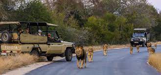
Kruger National Park
South Africa
6 Days | from $3,300 per person
Ruger National Park is a South African National Park and one of the largest game reserves in Africa. It covers an area of 19,623 km2 (7,576 sq mi) in the provinces of Limpopo and Mpumalanga in northeastern South Africa, and extends 360 km (220 mi) from north to south and 65 km (40 mi) from east to west. The administrative headquarters are in Skukuza. Areas of the park were first protected by the government of the South African Republic in 1898, and it became South Africa's first national park in 1926. To the west and south of the Kruger National Park are the two South African provinces of Limpopo and Mpumalanga, respectively. To the north is Zimbabwe, and to the east is Mozambique. It is now part of the Great Limpopo Transfrontier Park, a peace park that links Kruger National Park with the Gonarezhou National Park in Zimbabwe, and with the Limpopo National Park in Mozambique. The park is part of the Kruger to Canyons Biosphere, an area designated by the United Nations Educational, Scientific and Cultural Organization (UNESCO) as an International Man and Biosphere Reserve. The park has nine main gates allowing entrance to the different camps.
Location and geography
The park lies in the north-east of South Africa,[9] in the eastern parts of Limpopo and Mpumalanga provinces. Phalaborwa, Limpopo is the only town in South Africa that borders the Kruger National Park. It is one of the largest national parks in the world, with an area of 19,485 km2 (7,523 sq mi). The park is approximately 360 km (220 mi) long, and has an average width of 65 km (40 mi). At its widest point, the park is 90 km (56 mi) wide from east to west. To the north and south of the park two rivers, the Limpopo and the Crocodile respectively, act as its natural boundaries. To the east the Lebombo Mountains separate it from Mozambique. Its western boundary runs parallel with this range, roughly 65 km (40 mi) distant. The park varies in altitude between 200 m (660 ft) in the east and 840 m (2,760 ft) in the south-west near Berg-en-Dal. The highest point in the park is here, a hill called Khandzalive. Several rivers run through the park from west to east, including the Sabie, Olifants, Crocodile, Letaba, Luvuvhu and Limpopo Rivers.